Exploring Garfagnana and the Serchio Valley
Exploring Garfagnana and the Serchio Valley
he main road to explore the area is the Garfagnana Regional Road 445, which follows the Serchio river and passes by the Passo dei Carpinelli. This point links the Abetone and Brenner Road with the Cisa highway (A15) at Aulla.
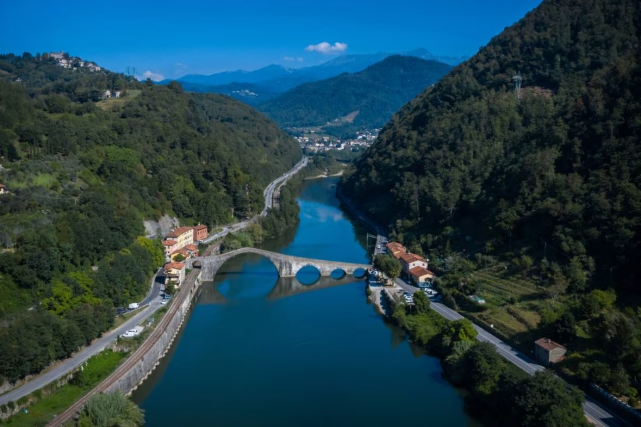
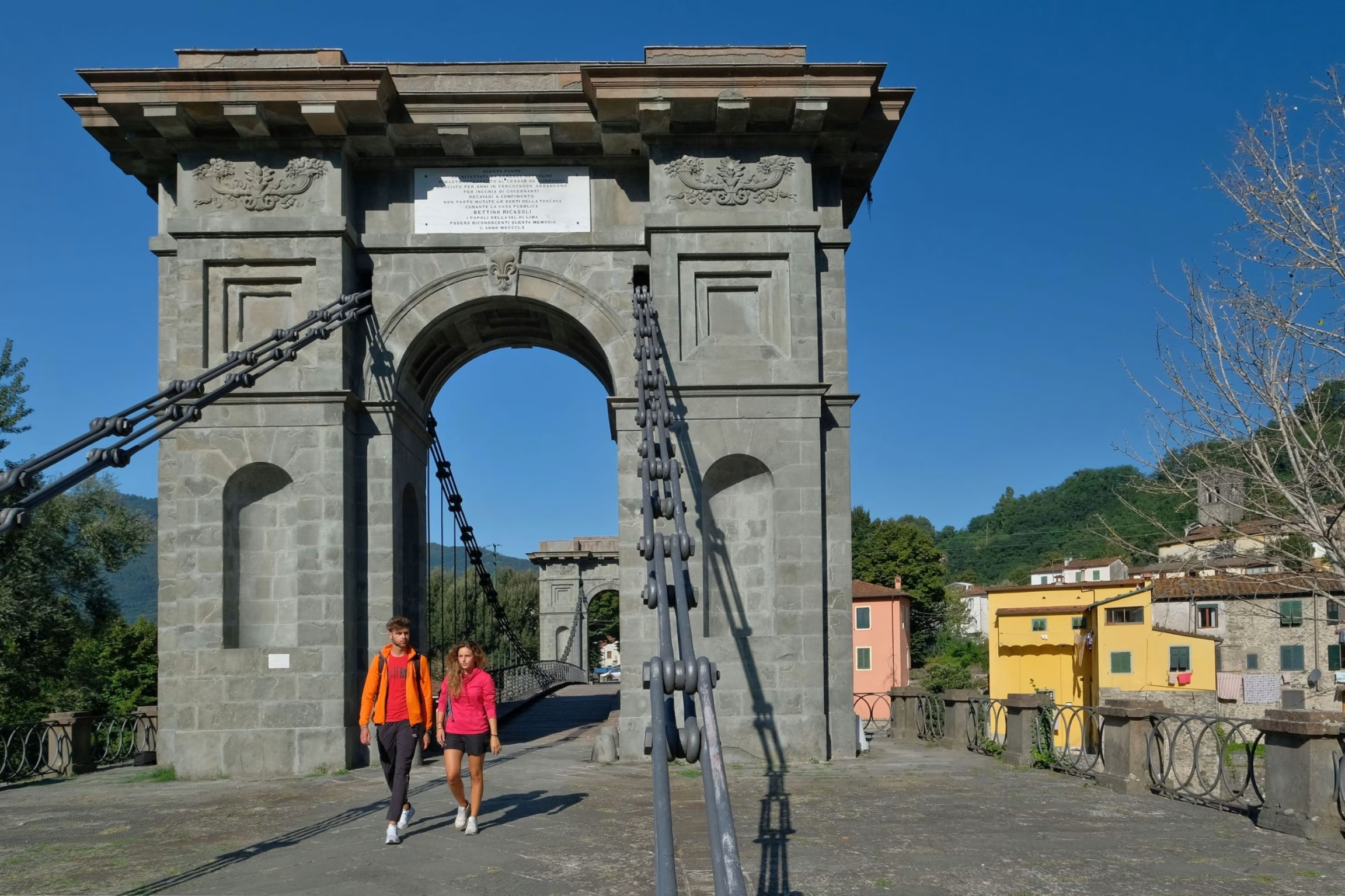
The valley’s symbolic entry point is the majestic Ponte della Maddalena (Maddalena’s Bridge), known as Ponte del Diavolo (Devil’s Bridge) in Borgo a Mozzano. Ponte di Ceserana provides direct access to the Tre Terre (the Three Lands) located in Fosciandora. There are many alternative roadways and routes which connect various hamlets and offer breathtaking views of the numerous Apennine and Apuan Alps mountain passes, including:
- Passo di Pradarena
- Passo delle Radici
- Passo dell’Oppio
- Passo del Vestito
- Passo del Cipollaio
- Passo del Lucese
Whether you are a two-wheel enthusiast or a traveler looking for spectacular views, Garfagnana and Serchio Valley offers you an unforgettable experience between nature and culture
Road Trips
Road Trips
1

The heart of the Southern Apuan Alps
This itinerary leads right into the heart of the Southern Apuan Alps. Starting from Borgo a Mozzano, famous for the Ponte del Diavolo (Devil’s Bridge), it is worth paying a visit to the Gothic Line Museum. From Diecimo onwards, the Valle Pedogna provincial road is dotted with various landmarks: the smallest theatre in the world, now belonging to FAI (The National Trust for Italy), in Vetriano; the Chestnut Museum in Colognora di Pescaglia; and in Celle Puccini, the house-museum where the great musician, Puccini, spent his holidays when he was just a boy. In Pescaglia, a diversion from the itinerary is recommended in order to see the Galgani ironworks: here there is still one blacksmith who forges iron following techniques developed over the centuries, creating agricultural tools as well as ‘testi’, indispensable tools for cooking the famous ‘necci’ with ricotta cheese, the ‘crisciolette’ or the ‘focacce leve’, simple and delicious peasant dishes. The itinerary continues to Foce di Bucine and from here, a narrow road reaches Alto Matanna, a timeless place where animals graze freely and from where, at just a short walk’s distance, it is possible to enjoy one of the most beautiful views of the Versilia coastline. From Bucine the itinerary then descends towards Fabbriche di Vallico, and its ancient watermill and characteristic Colandi bridge. Another ancient mill is the starting point of the Rio Selvano canyoning route.
A little further on, the Turrite Cava lake with its emerald green waters offers an inviting break before taking the road back into the valley.
Borgo a Mozzano
Pescaglia
Fabbriche di Vallico
Borgo a Mozzano
Pescaglia
Fabbriche di Vallico
The heart of the Southern Apuan Alps
This itinerary leads right into the heart of the Southern Apuan Alps. Starting from Borgo a Mozzano, famous for the Ponte del Diavolo (Devil’s Bridge), it is worth paying a visit to the Gothic Line Museum. From Diecimo onwards, the Valle Pedogna provincial road is dotted with various landmarks: the smallest theatre in the world, now belonging to FAI (The National Trust for Italy), in Vetriano; the Chestnut Museum in Colognora di Pescaglia; and in Celle Puccini, the house-museum where the great musician, Puccini, spent his holidays when he was just a boy. In Pescaglia, a diversion from the itinerary is recommended in order to see the Galgani ironworks: here there is still one blacksmith who forges iron following techniques developed over the centuries, creating agricultural tools as well as ‘testi’, indispensable tools for cooking the famous ‘necci’ with ricotta cheese, the ‘crisciolette’ or the ‘focacce leve’, simple and delicious peasant dishes. The itinerary continues to Foce di Bucine and from here, a narrow road reaches Alto Matanna, a timeless place where animals graze freely and from where, at just a short walk’s distance, it is possible to enjoy one of the most beautiful views of the Versilia coastline. From Bucine the itinerary then descends towards Fabbriche di Vallico, and its ancient watermill and characteristic Colandi bridge. Another ancient mill is the starting point of the Rio Selvano canyoning route.
A little further on, the Turrite Cava lake with its emerald green waters offers an inviting break before taking the road back into the valley.
Bagni di Lucca
Val di Lima
Orrido di Botri
Coreglia Antelminelli
2
Ancient thermal springs and valleys abundant in water
Already well known in Roman times, the thermal springs of Bagni di Lucca became a holiday destination for many illustrious clients in the 19th century. After leaving the elegant historic centre, with its Casino, Teatro Accademico, and numerous villa, the SS12 roads leads towards Abetone, running along the Lima torrent, a true paradise for outdoor activities lovers, passing by the Strette di Cocciglia to Lucchio, the town furthest away from Lucca. From Palleggio, following the signs for San Cassiano di Controne and its Romanesque parish church, the road reaches Montefegatesi, an ancient hamlet set on a rocky spur at an altitude of 850 metres, a splendid panoramic point. From here, the road descends along a few hairpin bends to Ponte a Gaio, the entrance to the Orrido di Botri canyon, a National Nature Reserve. The itinerary continues through Tereglio, Lucignana, Gromignana all the way to Coreglia Antelminelli, where it is possible to visit the Museum of Chalk Statuettes and Emigration. The road then descends with wide bends towards the bottom of the valley, for a final visit to the Castruccio Castracani a Ghivizzano castle.
Bagni di Lucca
Val di Lima
Orrido di Botri
Coreglia Antelminelli

Ancient thermal springs and valleys abundant in water
Already well known in Roman times, the thermal springs of Bagni di Lucca became a holiday destination for many illustrious clients in the 19th century. After leaving the elegant historic centre, with its Casino, Teatro Accademico, and numerous villa, the SS12 roads leads towards Abetone, running along the Lima torrent, a true paradise for outdoor activities lovers, passing by the Strette di Cocciglia to Lucchio, the town furthest away from Lucca. From Palleggio, following the signs for San Cassiano di Controne and its Romanesque parish church, the road reaches Montefegatesi an ancient hamlet set on a rocky spur at an altitude of 850 metres, a splendid panoramic point. From here, the road descends along a few hairpin bends to Ponte a Gaio, the entrance to the Orrido di Botri canyon, a National Nature Reserve. The itinerary continues through Tereglio, Lucignana, Gromignana all the way to Coreglia Antelminelli, where it is possible to visit the Museum of Chalk Statuettes and Emigration. The road then descends with wide bends towards the bottom of the valley, for a final visit to the Castruccio Castracani a Ghivizzano castle.

The great cave, the hermitage in the rock, the Romanesque cathedral
From Gallicano, overlooked by the Romanesque church of San Jacopo, the road enters the Turrite valley. In this valley, the Hermitage of Calomini set in the rock stands out clearly. Further ahead, the route leads to the Trombacco lake, located between deep gorges. It then reaches the hamlet of Fornovolasco and continues to go upwards through the woods where, after a few minutes, it reaches the Grotta del Vento (wind cave), one of the best-known tourist caves in the world. The magical underground world of karstic cavities is enclosed in three different guided itineraries. Easy paths and airy staircases allow visitors to observe and admire stalactites and stalagmites, alabaster draperies and underground streams. An alternative itinerary follows the road from Grotta to Vergemoli and then returns to Gallicano. From Gallicano the route continues towards Loppia and its Parish Church of Santa Maria Assunta, one of the oldest in the valley, to then continue towards Barga, one of the most stunning hamlets in Italy. Here, the narrow, cobbled streets of the historic centre, bordered by elegant Renaissance buildings, lead to the top of the village, where the imposing Romanesque Cathedral of San Cristoforo stands. Here it is possible to admire one of the most beautiful panoramic views of the Apuan Alps and Monte Forato. Not far from Barga, in Castelvecchio Pascoli, it is possible to visit the poet Giovanni Pascoli’s House-Museum.
Gallicano
Grotta del Vento
Barga
Castelvecchio Pascoli
3
Gallicano
Grotta del Vento
Barga
Castelvecchio Pascoli
The great cave, the hermitage in the rock, the Romanesque cathedral
From Gallicano, overlooked by the Romanesque church of San Jacopo, the road enters the Turrite valley. In this valley, the Hermitage of Calomini set in the rock stands out clearly. Further ahead, the route leads to the Trombacco lake, located between deep gorges. It then reaches the hamlet of Fornovolasco and continues to go upwards through the woods where, after a few minutes, it reaches the Grotta del Vento (wind cave), one of the best-known tourist caves in the world. The magical underground world of karstic cavities is enclosed in three different guided itineraries. Easy paths and airy staircases allow visitors to observe and admire stalactites and stalagmites, alabaster draperies and underground streams. An alternative itinerary follows the road from Grotta to Vergemoli and then returns to Gallicano. From Gallicano the route continues towards Loppia and its Parish Church of Santa Maria Assunta, one of the oldest in the valley, to then continue towards Barga, one of the most stunning hamlets in Italy. Here, the narrow, cobbled streets of the historic centre, bordered by elegant Renaissance buildings, lead to the top of the village, where the imposing Romanesque Cathedral of San Cristoforo stands. Here it is possible to admire one of the most beautiful panoramic views of the Apuan Alps and Monte Forato. Not far from Barga, in Castelvecchio Pascoli, it is possible to visit the poet Giovanni Pascoli’s House-Museum.
4

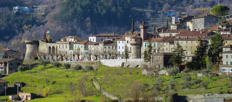
West of the Serchio, overlooking the Apuan Alps
Molazzana is a unique territory which extends from the right bank of the Serchio river to the summit of the Pania della Croce (1859 m). This area is rich in vineyards and olive-groves, chestnut woods and beech forests and, higher above, there are the limestone ramparts of the ‘queen of the Apuan Alps’.
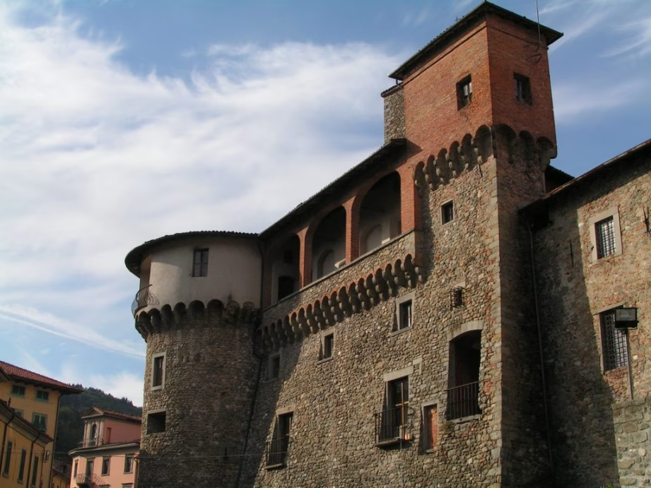
Just below Pania, the Alpe di S. Antonio is the municipality’s hamlet located at the highest altitude. Here, in the small cemetery lie the mortal remains of the internationally renowned anthropologist Fosco Maraini, who had chosen Pasquigliora as his mountain retreat. Descending the mountain, the road encounters Eglio and Sassi, two hamlets located in a breathtakingly beautiful panoramic position where visitors can visit the ancient church of S. Frediano and its bell tower, built on an older fortress destroyed in 1370. The castle of Este origin (15th century) overlooks Molazzana where the old town school has been turned into the Garfagnana Gothic Line Museum which provides information on the itineraries regarding the military posts of Grottorotondo.
Cascio is a fortified hamlet and has impressive city walls, gates and towers dating back to 1615. The name of the town is linked to a gastronomic excellence of Garfagnana: the Criscioletta, celebrated in the village festival celebrated for the first time in 1969 in honour of the patron saint.
Gallicano
Monteperpoli
Cascio
Montaltissimo
Sassi
Alpe S. Antonio
Molazzana
Gallicano
Monteperpoli
Cascio
Montaltissimo
Sassi
Alpe S. Antonio
Molazzana

West of the Serchio, overlooking the Apuan Alps
Molazzana is a unique territory which extends from the right bank of the Serchio river to the summit of the Pania della Croce (1859 m). This area is rich in vineyards and olive-groves, chestnut woods and beech forests and, higher above, there are the limestone ramparts of the ‘queen of the Apuan Alps’.
Just below Pania, the Alpe di S. Antonio is the municipality’s hamlet located at the highest altitude. Here, in the small cemetery lie the mortal remains of the internationally renowned anthropologist Fosco Maraini, who had chosen Pasquigliora as his mountain retreat. Descending the mountain, the road encounters Eglio and Sassi, two hamlets located in a breathtakingly beautiful panoramic position where visitors can visit the ancient church of S. Frediano and its bell tower, built on an older fortress destroyed in 1370. The castle of Este origin (15th century) overlooks Molazzana where the old town school has been turned into the Garfagnana Gothic Line Museum which provides information on the itineraries regarding the military posts of Grottorotondo.
Cascio is a fortified hamlet and has impressive city walls, gates and towers dating back to 1615. The name of the town is linked to a gastronomic excellence of Garfagnana: the Criscioletta, celebrated in the village festival celebrated for the first time in 1969 in honour of the patron saint.
Castiglione di Garfagnana
S.Pellegrino in Alpe
Pieve Fosciana
5

The Highest Village and the Fortified Town
Following the SP 72 Passo delle Radici road from Castelnuovo, after just a few kilometres, drivers encounter the fortified town of Castiglione Garfagnana, one of the most beautiful hamlets in Italy. The road continues and passes by Cerageto, Sassorosso and Massa Sassorosso, the hometown of the ancestors of the great musician Astor Piazzoll, commemorated by several plaques placed around the town; further on, after the Casone di Profecchia winter sports location, the route leads to the impressive Passo delle Radici (1529 m above sea level), where the road continues along the Emilian side of the mountains. On the right, a road ascends to the small village of San Pellegrino in Alpe; here the views are magnificent and overlook the entire valley as far as the plain of Lucca. The ‘Don Luigi Pellegrini’ ethnographic museum and the sanctuary where the remains of Saints Pellegrino and Bianco lie, are worth a visit. The itinerary continues downhill in the direction of Chiozza and then returns back to Pieve Fosciana, where visitors can visit the parish church of San Giovanni Battista, the water mill, still operating today. Nearby is Pontecosi with its medieval hump-backed bridge and the church of San Magno.
Castiglione di Garfagnana
S.Pellegrino in Alpe
Pieve Fosciana
The Highest Village and the Fortified Town
Following the SP 72 Passo delle Radici road from Castelnuovo, after just a few kilometres, drivers encounter the fortified town of Castiglione Garfagnana, one of the most beautiful hamlets in Italy. The road continues and passes by Cerageto, Sassorosso and Massa Sassorosso, the hometown of the ancestors of the great musician Astor Piazzoll, commemorated by several plaques placed around the town; further on, after the Casone di Profecchia winter sports location, the route leads to the impressive Passo delle Radici (1529 m above sea level), where the road continues along the Emilian side of the mountains. On the right, a road ascends to the small village of San Pellegrino in Alpe; here the views are magnificent and overlook the entire valley as far as the plain of Lucca. The ‘Don Luigi Pellegrini’ ethnographic museum and the sanctuary where the remains of Saints Pellegrino and Bianco lie, are worth a visit. The itinerary continues downhill in the direction of Chiozza and then returns back to Pieve Fosciana, where visitors can visit the parish church of San Giovanni Battista, the water mill, still operating today. Nearby is Pontecosi with its medieval hump-backed bridge and the church of San Magno.
6

The stronghold, the fortress and Isola Santa
Castelnuovo, with its Romanesque cathedral, Rocca Ariostesca and the Mont’Alfonso Fortress is the political centre of the valley where, every Thursday, since 1430, the open-air market animates the town. The provincial road leading to Versilia starts from here and skirts the Turrite Secca, a famous Apuan torrent, located deep inside a gorge. After a few kilometres, the road leads to the Isola Santa lake (Holy Island). On the lake’s shores stands the ancient hamlet, characterised by typical buildings with stone slab roofs. Continuing, the scenery opens up on the rocky walls of Monte Sumbra, with the ‘Marmitte dei Giganti’ (Caverns of the Giants), characteristic erosion in the rock created by the combined action of stones and water. At Tre Fiumi, the main road ascends to the Cipollaio tunnel to then reach the Versilian coast. However, at Tre Fiumi, visitors can opt for the road on the right and reach Arni and the Monte Pelato tunnel (Passo del Vestito). On the way back, just before Isola Santa, there is a road on the left that goes up to Capanne di Careggine and the Maestà della Formica and then descends towards the village of Careggine located on a plateau with a splendid panorama. Here, during the winter season, it’s possible to ski while during the other seasons there are fascinating and exciting hikes in the centuries-old chestnut forest. Once in Poggio, a visit to the small Romanesque church of S. Biagio and the Rocca Estense di Camporgiano is a must.
Castelnuovo di Garfagnana
Isola Santa
Altopiano di Careggine
Camporgiano
Castelnuovo di Garfagnana
Isola Santa
Altopiano di Careggine
Camporgiano
The stronghold, the fortress and Isola Santa
Castelnuovo, with its Romanesque cathedral, Rocca Ariostesca and the Mont’Alfonso Fortress is the political centre of the valley where, every Thursday, since 1430, the open-air market animates the town. The provincial road leading to Versilia starts from here and skirts the Turrite Secca, a famous Apuan torrent, located deep inside a gorge. After a few kilometres, the road leads to the Isola Santa lake (Holy Island). On the lake’s shores stands the ancient hamlet, characterised by typical buildings with stone slab roofs. Continuing, the scenery opens up on the rocky walls of Monte Sumbra, with the ‘Marmitte dei Giganti’ (Caverns of the Giants), characteristic erosion in the rock created by the combined action of stones and water. At Tre Fiumi, the main road ascends to the Cipollaio tunnel to then reach the Versilian coast. However, at Tre Fiumi, visitors can opt for the road on the right and reach Arni and the Monte Pelato tunnel (Passo del Vestito). On the way back, just before Isola Santa, there is a road on the left that goes up to Capanne di Careggine and the Maestà della Formica and then descends towards the village of Careggine located on a plateau with a splendid panorama. Here, during the winter season, it’s possible to ski while during the other seasons there are fascinating and exciting hikes in the centuries-old chestnut forest. Once in Poggio, a visit to the small Romanesque church of S. Biagio and the Rocca Estense di Camporgiano is a must..

The two great lakes and the green alpine pastures
This itinerary focuses on the peculiarities of the Apuan Alps Regional Park. Along the road which leads to Vagli Sotto, there is the artificial lake of Vagli, which hides the abandoned village of Fabbriche di Careggine in its deep waters; when the lake is emptied, the ancient village founded by ironmongers from Brescia, springs back to life. The parish church of San Regolo and the Romanesque church of S. Agostino (11th century) are worth a visit. After reaching Vagli di Sopra, Campocatino is just a short walk away. This is an ancient shepherds’ pasture, set on the edge of the large meadow at the foot of Mount Roccandagia. From here, the Hermitage of S. Viano can be reached on foot in about 30 minutes. From Campocatino walkers then descend to Gorfigliano, where the mediaeval complex of the Chiesa Vecchia and the Alta Garfagnana Identity can be visited. At Gramolazzo, Monte Pisanino is reflected in the clear waters of the artificial lake. With a diversion of a few kilometres, visitors can reach the glacial valley of Orto di Donna - Serenaia, surrounded by the highest peaks of the entire Apuan Alps.
Lago di Vagli
Campocatino
Lago di Gramolazzo
7
Lago di Vagli
Campocatino
Lago di Gramolazzo

The two great lakes and the green alpine pastures
This itinerary focuses on the peculiarities of the Apuan Alps Regional Park. Along the road which leads to Vagli Sotto, there is the artificial lake of Vagli, which hides the abandoned village of Fabbriche di Careggine in its deep waters; when the lake is emptied, the ancient village founded by ironmongers from Brescia, springs back to life. The parish church of San Regolo and the Romanesque church of S. Agostino (11th century) are worth a visit. After reaching Vagli di Sopra, Campocatino is just a short walk away. This is an ancient shepherds’ pasture, set on the edge of the large meadow at the foot of Mount Roccandagia. From here, the Hermitage of S. Viano can be reached on foot in about 30 minutes. From Campocatino walkers then descend to Gorfigliano, where the mediaeval complex of the Chiesa Vecchia and the Alta Garfagnana Identity can be visited. At Gramolazzo, Monte Pisanino is reflected in the clear waters of the artificial lake. With a diversion of a few kilometres, visitors can reach the glacial valley of Orto di Donna – Serenaia, surrounded by the highest peaks of the entire Apuan Alps.
Villa Collemandina
Parco dell’Orecchiella
Fortezza di Verrucole
San Romano in Garfagnana
8
Apennine biodiversity and the majestic fortress
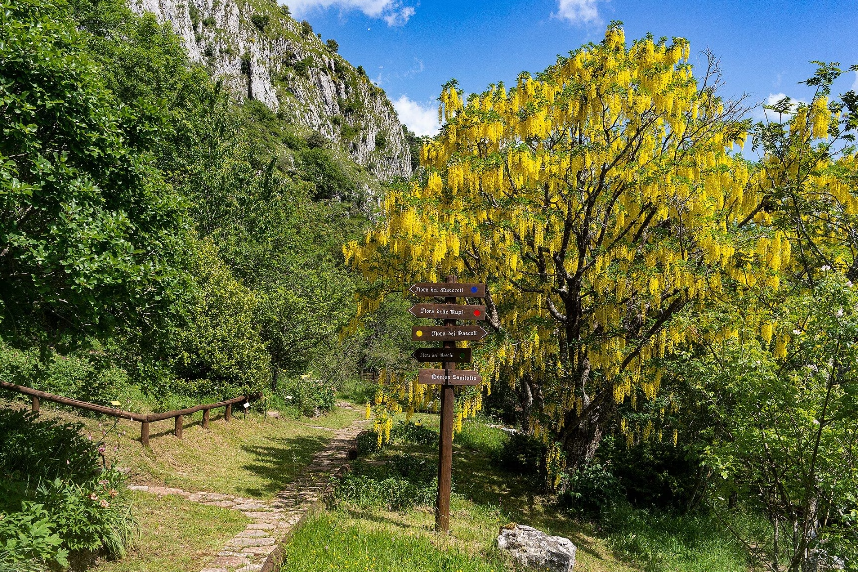
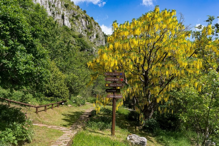
The Orecchiella Nature Reserves are the pride of the Tuscan-Emilian Apennine National Park, an area of rare scenic beauty, representative of the Apennine flora and fauna. Here deer, mouflon, roe deer, wild boar and wolves, as well as many species of birds, both resident and migratory, have found their ideal habitat. The golden eagle, which has always been present on Pania di Corfino, hunts all the way to the high peaks of Monte Prato and Monte Vecchio. The Orecchiella Park Visitor Centre can be reached from Castelnuovo Garfagnana by following the signs for Villa Collemandina and Corfino. In the Park, a ‘facilitated’ route leads visitors to the fauna observation areas. The Mountain Flower Garden, with its stunning summer blooms, and the ‘Pania di Corfino’ Botanical Garden will captivate nature enthusiasts. The itinerary continues along the road which leads to S. Romano in Garfagnana, passing through the towns of Caprignana (where travellers can take an evocative walk through the streets, the countryside and chestnut groves located in Caprignana vecchia, a village abandoned following the 1920 earthquake) and Orzaglia. The road then reaches the Verrucole Fortress, one of the most imposing and representative monuments of Garfagnana and the system of military fortifications still standing today.
Villa Collemandina
Parco dell’Orecchiella
Fortezza di Verrucole
San Romano in Garfagnana
Apennine biodiversity and the majestic fortress
The Orecchiella Nature Reserves are the pride of the Tuscan-Emilian Apennine National Park, an area of rare scenic beauty, representative of the Apennine flora and fauna. Here deer, mouflon,roe deer, wild boar and wolves, as well as many species of birds, both resident and migratory, have found their ideal habitat. The golden eagle, which has always been present on Pania di Corfino, hunts all the way to the high peaks of Monte Prato and Monte Vecchio. The Orecchiella Park Visitor Centre can be reached from Castelnuovo Garfagnana by following the signs for Villa Collemandina and Corfino. In the Park, a ‘facilitated’ route leads visitors to the fauna observation areas. The Mountain Flower Garden, with its stunning summer blooms, and the ‘Pania di Corfino’ Botanical Garden will captivate nature enthusiasts. The itinerary continues along the road which leads to S. Romano in Garfagnana, passing through the towns of Caprignana (where travellers can take an evocative walk through the streets, the countryside and chestnut groves located in Caprignana vecchia, a village abandoned following the 1920 earthquake) and Orzaglia. The road then reaches the Verrucole Fortress, one of the most imposing and representative monuments of Garfagnana and the system of military fortifications still standing today.
Argegna
Giuncugnano
Sillano

The Apennine passes, exploring nature
After visiting the mediaeval village of San Michele, from Piazza al Serchio – the road junction of the upper valley – the SR 445 road goes up to the Passo dei Carpinelli, passing through ample spelt fields. This kind of wheat has been awarded the IGP (Protected Geographical Indication) label and is used in many typical Garfagnana dishes. From the pass, the main road descends into the Lunigiana valley, known for its castles and mysterious Statue Steli. Proceeding once again upwards, drivers encounter the Argegna plateau, where the Madonna della Guardia white Sanctuary stands out clearly against the large meadow located at the summit. After a visit to the Ospitale di Tea archaeological site, the road leads to Giuncugnano. From here, by following the signs for Magliano and Ponteccio, the route returns to the main road which will guide visitors inside the Tuscan-Emilian Apennine National Park, amidst large forest areas. After having passed Dalli di Sopra e Dalli di Sotto, the itinerary leds to Sillano and the Provincial road of Pradarena. A short climb leads right to the historic pass that connects Garfagnana with the province of Reggio Emilia. From Sillano the intnerary enters into the Soraggio Valley, offering sweeping views over exquisite landscapes and, after passing by the Vicaglia Lake, the road enters the Orecchiella area to then descend towards Piazza al Serchio from Orzaglia.
The Highest Village
and the Fortified Town
Following the SP 72 Passo delle Radici road from Castelnuovo, after just a few kilometres, drivers encounter the fortified town of Castiglione Garfagnana, one of the most beautiful hamlets in Italy. The road continues and passes by Cerageto, Sassorosso and Massa Sassorosso, the hometown of the ancestors of the great musician Astor Piazzoll, commemorated by several plaques placed around the town; further on, after the Casone di Profecchia winter sports location, the route leads to the impressive Passo delle Radici (1529 m above sea level), where the road continues along the Emilian side
of the mountains. On the right, a road ascends to the small village of San Pellegrino in Alpe; here the views are magnificent and overlook the entire valley as far as the plain of Lucca. The ‘Don Luigi Pellegrini’ ethnographic museum and the sanctuary where the remains of Saints Pellegrino and Bianco lie, are worth a visit. The itinerary continues downhill in the direction of Chiozza and then returns back to Pieve Fosciana, where visitors can visit the parish church of San Giovanni Battista, the water mill, still operating today. Nearby is Pontecosi with its medieval hump-backed bridge and the church of San Magno.
roe deer, wild boar and wolves, as well as many species of birds, both resident and migratory, have found their ideal habitat. The golden eagle, which has always been present on Pania di Corfino, hunts all the way to the high peaks of Monte Prato and Monte Vecchio. The Orecchiella Park Visitor Centre can be reached from Castelnuovo Garfagnana by following the signs for Villa Collemandina and Corfino. In the Park, a ‘facilitated’ route leads visitors to the fauna observation areas. The Mountain Flower Garden, with its stunning summer blooms, and the ‘Pania di Corfino’ Botanical Garden will captivate nature enthusiasts. The itinerary continues along the road which leads to S. Romano in Garfagnana, passing through the towns of Caprignana (where travellers can take an evocative walk through the streets, the countryside and chestnut groves located in Caprignana vecchia, a village abandoned following the 1920 earthquake) and Orzaglia. The road then reaches the Verrucole Fortress, one of the most imposing and representative monuments of Garfagnana and the system of military fortifications still standing today.